Categories
Mapping Visualization

Native Land

Native Land visualizes the territories and languages of native peoples (primarily in North America and Australia), and the treaties which affected those people. Users can search by location to discover on what native lands that location resides, what languages were spoken, and what treaties impacted the native people living there.

Native Land map showing the location of modern day Lewisburg, PA as being on the land of the Susquehannock people.

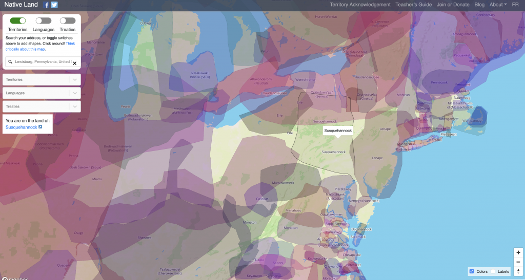
Native Land was created in 2015 by Victor Temprano, a settler hailing from Okanagan territory in Canada. As of 2018, Native Land Digital is a Canadian not-for-profit organization, and is designed to be Indigenous-led, with an Indigenous Board of Directors who oversee and direct the organization.

Categories
Archive Mapping Visualization

Navigating the Green Book

The Green Book was a travel guide published between 1936 and 1966 that listed hotels, restaurants, bars, gas stations, etc., where black travelers would be welcome. Developers at the New York Public Library have extracted data from the 1947 and 1956 editions of the Green Book and developed the Navigating the Green Book interface through which users can explore and visualize the data.

Through the map interface, you can plot a trip and see locations where black travelers would have been welcomed along your route.
Categories
Mapping Visualization

American Panorama

American Panorama is an historical atlas of the United States which combines cutting-edge research with interactive mapping techniques. Hosted by the University of Richmond, American Panorama includes several projects which examine United States history through a critical lens and foreground the lasting impacts of racially-based policies. Mapping Inequality: Redlining in New Deal America visualizes hundreds of Home Owners’ Loan Corporation maps created between 1935 and 1940, and reveals the ways in which cities were “graded” for potential home buyers along racial lines. Renewing Inequality: Family Displacements through Urban Renewal, 1950-1966 visualizes the impact of federal government government programs that provided funding for cities large and small to raze “blighted” or “slum” neighborhoods.

The front page of the Renewing Inequality project.

Categories
Mapping Visualization

Torn Apart / Separados

Torn Apart is part of our Mobilized Humanities interventions. MH brings together digital tools to equip broad social awareness and help in global critical situations. We mobilize humanities faculties, libraries, and students with relevant language, archival, technical, and social expertise to nimbly produce curated and applied knowledge. MH sits away from state and non-governmental organizations and is scholarly activism in a global context.” The project currently has two volumes, each of which present multiple visualizations of data related to the current immigration crises in the United States.

Visualization from Volume 1 of Torn Apart

Volume 1 of Torn Apart is “a rapidly deployed critical data & visualization intervention in the USA’s 2018 “Zero Tolerance Policy” for asylum seekers at the US Ports of Entry and the humanitarian crisis that has followed.”

Visualization from Volume 2 of Torn Apart

Volume 2 of Torn Apart examines the territory and infrastructure of ICE’s financial regime in the USA. 

Categories
Crowdsourcing Mapping Visualization

Queering the Map

Each point on the map represents a location of queer experience.

Queering the Map is a community-generated mapping project that geo-locates queer moments, memories and histories in relation to physical space. As queer life becomes increasingly less centered around specific neighborhoods and the buildings within them, notions of ‘queer spaces’ become more abstract and less tied to concrete geographical locations. The intent of the Queering the Map project is to collectively document the spaces that hold queer memory, from park benches to parking garages, to mark moments of queerness wherever they occur.” The project was developed by Lucas LaRochelle, a design student at Concordia University in Montreal.